|
UV index forecast and archives |
|||||||||||||||||||||
Tropospheric
|
||||||||||||||||||||||
|
|
|
NO2
- global CH2O - global |
|
|
|
UV
- UV index - UV dose |
|
|
|
Ozone
- total column - global field - ozone hole - ozone profiles |
|
|
|
Aerosol
- ADRE - aerosol index Clouds - cloud info Surface - solar irradiance |
|
|
|
Volcanic plume
- SO2 & AAI |
|
|
|
Albedo
- climatologies Fluorescence - sun-induced |
February 2026
Clear-sky UV index forecast
The clear-sky UV index is a measure for the effective UV irradiance (1 unit equals 25 mW/m2) reaching the Earth's surface. The clear-sky UV index is based on the CIE action spectrum for the susceptibility of the caucasian skin to sunburn (erythema) and it is valid for cloud-free conditions at local solar noon, i.e. when the sun is highest in the sky.
Forecasts are provided for today (shown below) and the next few days (follow links below the maps). Only the forecast UV index maps for today are available in the WHO colours; all other maps are in the default TEMIS UV colour bar. See below for some notes on the UV index colour bar.
-
Data:
Today and coming days at your location
Maps: Europe | Benelux | Dutch Caribbean & Suriname | World
Archives
- version 2.0-2.2:
- Erythemal UV index
- UV index timeseries at selected locations
- Overview of all archives
-
- versions 1.2-1.4:
- versions 1.2-1.4:
- Data is no longer available
Notes on the UV index colour bar
The international definition of the UV index is coordinated by the World Health Organisation (WHO). In the communication to the public the UV index is rounded to integers (1,2,3,...), where the value 0 (zero) is not used, and the scale runs up to 11. For each of these UV index levels specific colours are defined (see page 22 of this PDF):

The TEMIS UV data itself is available in real numbers (with three decimals) and the default colour map for the TEMIS UV data is chosen to show a large range of variability, where different maps have different upper limits of the scale.

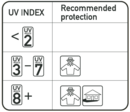
The WHO recommends
to apply protection
when the UV index
is 3 or higher.
Related information
- General data product description of version 2.0-2.2
- Structure and reading
of the daily HDF-4 data files
and the yearly netCDF data files (v2.0 and above). - Information for the Dutch public at the RIVM website (in Dutch):
- Zonkracht en UV == general page
- Zonkrachtwijzer == cloud-modified UV index for today
- Zonkrachtmetingen bij RIVM == today's actual UV index at Bilthoven
-
UV index forecast of KNMI for The Netherlands (in Dutch)
- Short introduction to UV index and UV dose
- World Health Organisation (WHO) information:
- R package UVdose:
Estimate ambient UV dose from location and date info,
which uses TEMIS data. - Publications and references for the
TEMIS UV data services and datasets
- KNMI nieuws- en achtergrondberichten met of in relatie
tot TEMIS UV data (Dutch only):
- 16 juni 2022: Lange dagen met sterke zonkracht
- 1 juni 2021: Waarom het beter is om eind van de dag van de zon te genieten
- 14 aug. 2018:
Zonkracht in zonovergoten zomer
( zie ook het corresponderende RIVM artikel ) - 8 juni 2018: Meer zon, iets minder zonkracht
- 24 juni 2017: Snel verbrand door sterke zonkracht
- 19 juni 2017: Zonkracht, blauwe lucht en flarden hoge bewolking


